


The sea is one of the most vast areas and with the least bordering limitations, therefore, if you own ships or boats, it is very important to know your location and trajectory. Nowadays, all this is possible and simple thanks to technology. It is also very useful for rental boats in Ibiza. There are several applications and web pages that offer boat location services equipped with AIS systems, an economic system, novel, efficient and with a range of surprising coverage.
When using AIS localization services, you can check the location of your vessel or maritime fleet from your PC or smart phone. In the same way, locating boats of friends, yachts, fishing boats and even a merchant ship, will be easy through these applications and web pages. The option to track merchant ships has become very popular among merchants, since knowing the exact location of the ship that carries their merchandise is very important to provide accurate and timely information to their customers.
Vessel Finder: a free tracker for ships with AIS systems
The page Vessel Finder is one of the most interesting of the network. It has a friendly interface and understandable even by the most inexperienced. On the main page there is a map with a module where you can search for boats by name, MMSI or IMO number. By placing a boat name it will show you a lot of suggestions, being a great option to find the indicated boat. If you have accurate information, such as the MMSI or IMO number, Vessel Finder will quickly show you the ship’s location, trajectory and basic data. This page allows you to establish preferences through the section “My fleet”, so you can quickly and automatically consult all the necessary information of your favorite boats. If you are one of the most demanding users you can choose some options and payment services, which provide various specific information and statistics of the boats.

Vessel Finder has mobile applications compatible with Android and iOS operating systems. In this way, you can consult boat information at any place and time. Also, if you are a bit inexperienced in the subject you can enter the forum that provides the page, there you can interact with hundreds of users of AIS tracking services.
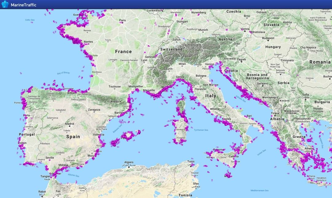
Marine Traffic: a smart option for tracking AIS vessels
The Marine Traffic page in its Spanish version is undoubtedly one of the best sites for tracking vessels with AIS systems. With just entering your page and automatically find a “live map”, with all the world traffic of ships and boats, you realize the great potential of this website. The Marine Traffic search box is similar to that of Vessel Finder. However, after conducting a search by name and choosing an option among the large number of vessels that it launches, the page shows a complete and detailed information of the vessel to be tracked. Flag of the ship, type of vessel, dimensions and identification are displayed on a new page. In the same way, the location according to the latest AIS report and trajectory. Speed and heading are complementary information that also shows the page as well as a referential photo of the vessel to know its physical characteristics. Marine Traffic maps are basic, but if you want a more visually detailed location, the page provides you with a link to view the location using coordinates in the popular Google maps.
The mobile applications of Marine Traffic are available in the iOS and Android operating systems. It should be noted that its two applications are the best valued in the nautical world. The MarineTraffic – Ship Tracking application is the most downloaded and is connected to the largest network of AIS receivers. With this tool designed for smartphones the user can check the location of boats anywhere in the world. MarineTraffic – Ship Tracking shows information related to wind speed and forecasts. Create animations of the boat route and track the position, speed and heading of the boat.
Vessel locator of the Spanish Institute of Oceanography
This website provides the location of ships with AIS system through an application that works in conjunction with the Google map. The page IEO provides the exact location of the IEO vessels. It is a very useful website for people interested in tracking ships. It also provides basic information on the location of the main maritime ports and infrastructures around the world. However, the IEO vessel locator suggests the services of Marine Traffic to consult all the world traffic.
OnCourse – boating & sailing nav (mAIS)
OnCourse – boating & sailing nav (mAIS) is the other application designed by Marine Traffic. This application shows a binnacle of maritime traffic around a vessel. It is ideal for planning routes and sharing the position of the boat with friends and family. In addition, you can also share and interact with other boaters.
Take a second to read the story of CharterAlia and how it became a remarkable boat hire in Ibiza.